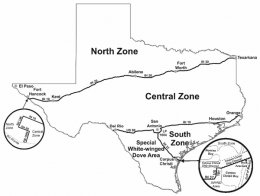
Colorado hunting Zone Map
 North ZoneThat portion of the state north of a line beginning at the International Bridge south of Fort Hancock; thence north along FM 1088 to State Highway 20; thence west along State Highway 20 to State Highway 148; thence north along State Highway 148 to Interstate Highway 10 at Fort Hancock; thence east along Interstate Highway 10 to Interstate Highway 20; thence northeast along Interstate Highway 20 to Interstate Highway 30 at Fort Worth; thence northeast along Interstate Highway 30 to the Texas-Arkansas state line.Central ZoneThat portion of the state between the North Zone and the South Zone.South ZoneThat portion of the state south of a line beginning at the International Toll Bridge in Del Rio; thence northeast along U.S. Highway 277 Spur to U.S. Highway 90 in Del Rio; thence east along U.S. Highway 90 to State Loop 1604; thence following Loop 1604 south and east, then north, to Interstate Highway 10; thence east along Interstate Highway 10 to the Texas-Louisiana Line.Special white-winged dove areaThat portion of the state south and west of a line beginning at the International Toll Bridge in Del Rio; thence northeast along U.S. Highway 277 Spur to U.S. Highway 90 in Del Rio; thence east along U.S. Highway 90 to State Loop 1604; thence along Loop 1604 south and east to Interstate Highway 37; thence south along Interstate Highway 37 to U.S. Highway 181 in Corpus Christi; thence north and east along U.S. 181 to the Corpus Christi Ship Channel, thence eastwards along the south shore of the Corpus Christi Ship Channel to the Gulf of Mexico.
|
Colorado Atlas & Gazetteer : Detailed Topographic Maps : Outdoor Recreation : Places to Go, Things to Do : All-Purpose Reference : Back Roads, Recreation Sites, GPS Grids - Eighth Edition 2007 Book (DeLorme) |


